Around Tilburg 13: South-West (Water extraction area, Gilze, Alphen, Bels Lijntje)
Tilburg, North Brabant, The Netherlands
Cycling route: 295528
Provided by: Boudewijn Waijers, Utrecht (NL)
01:59 h
Description
The route starts and ends at Tilburg University station. There is plenty of free parking here. Next to the station is café-restaurant Boerke Mutsaers , where you can find a charging point.
From the station, drive south and immediately turn right. Here you will find a small shopping center under some student flats. In the distance you can see the university . Just before the university, turn left and at café Het Dorstig Hert turn right onto Bredaseweg. This is the longest street in Tilburg.
A little further, on your right, is the Jewish cemetery (not open to visitors). A little further on you first pass Auberge Du Bonheur and later the fields of hockey club Tilburg. In between, on your right, is the Oude Warande , a city park that was built in 1712 by Willem van Hessen-Kassel and is one of the few still intact star forests in the Netherlands.
At junction 10 turn left and follow the Bels Lijntje for some time. This tourist cycle path follows the route of the former railway line to Belgium (\\\'Bels\\\' means'Belgian\\\' in the local dialect). Here you drive through the water extraction area of Brabant Water. At the Gilzerbaan you turn right, and a little later you pass the pumping station where not only drinking water for Central Brabant is extracted, but also bottled water is bottled: the Prize d\\\'Eau brand comes from here.
About a kilometer further, we are still driving in the water extraction area, you will find the Prize d\\\'Eau golf course on the left. Opposite here is a company that provides hot air balloon tours . Following the road you pass the highway to Breda, and a little further on you will find Speelboerderij De Vossenberg on your left. Here there is an indoor and outdoor playground, a craft and play attic, and a terrace for tired parents.
A little further on we arrive in Gilze. Here we first drive past the museum Dè Wascht en Strèkt (\\\'Dat Wast en Strijkt\\\'), where you can discover the history of laundry and ironing. The museum can only be visited by appointment. We drive through the center of Gilze past some catering establishments. At the end of a dead-end side street, Het Patronaat, you will find the cemetery, where a war memorial stands: De Klokkenstoel . We leave Gilze via the Alphensebaan, where café De Hooikar has a charging point for your electric bicycle.
We drive on. Where the Gilze ring road meets our road, the cycle path leads up along a dike. There is a sealing stone on the roadside here, belonging to the'Poosplaces\\\' project, which covers the Dutch border area between Tilburg and Breda. Continue following this road for some time until you turn right onto the Franse Baan. A little further, turn left, towards the't Zand recreation area . Drive past this recreational area and through the hamlet of the same name to junction 66, where you turn right in the direction of a small chapel. You can also turn right here towards Camping't Zand , where there is a charging point.
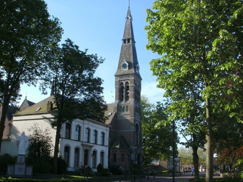
You drive back towards Alphen. At W. Binckplein you will find a café-restaurant and a war memorial. At the end of Heuvelstraat, at the back left of the square, you will find another charging point. We continue in a south-eastern direction and arrive at the old white church of Alphen, which is located at a junction. This church is now the regional museum of Alphen. We continue our way on the left past the church until we arrive (again) at the Bels Lijntje. Alphen station was located here until 1934; Nowadays you will find two café-restaurants here.
We follow the cycle path in the direction of Tilburg, past junctions 70 and 74. Here we briefly leave the Bels Lijntje and drive through Riel to junction 34. Here you can have a bite to eat or a drink, and opposite the Goirleseweg is a charging point. There is a good bicycle repair shop just in front of the church . A little further on you will see a war monument in a front garden on your right, and a little later you will return to the Bels Lijntje at junction 34. Near this last junction you will find the remains of an old mill at Zandeind. Follow the Bels Lijntje until you have passed under the A58.
You leave the Bels Lijntje and turn right. Shortly afterwards you turn left onto the Dongepad. You are here on an even older section of the Bels Lijntje, from before it was routed around Tilburg. Where you see the back of a sports hall on your right, turn left. The route takes you past Hofstede de Blaak , an authentic English country house with a tenant farm, in its current form dating from 1907. The showpiece is the hunting hall with oak paneling. Today it is a restaurant and community centre, which has won several awards, including the Bib Gourmand from Michelin for an excellent three-course menu for a reasonable price.
We return to the route of the Bels line and follow it in a northerly direction. After crossing the Baroniebaan, continue to follow the road. You cross the Bredaseweg again, and a little later you cross the Professor Cobbenhagenlaan on the Academielaan. As you can see from the street names, you are near the university again.
You continue straight ahead, and through a tunnel you finally arrive at the north side of the railway line. Here, follow the railway line in a westerly direction until you arrive at the end point of the route: Tilburg University station , where you also started.
Height Profile

© onbekend

© Hofstede de Blaak

© Onbekend

© breda-en-alles-daaromheen.nl

© campingcard.nl

© TracesOfWar.com

© VanDerWeegen.nl

© Tilburg University
© Kees Wittenbols

© TracesOfWar.com

© Onbekend

© Google Street View
You do not want to miss this
Below you will find various suggestions for breaks that you can visit during your route. These are divided into different categories, making it easy for you to choose.

Directions
| # | Description | Distance | |
|---|---|---|---|
| tilburg universiteit (NS Zonetaxi, 5042RM, Tilburg, North Brabant, The Netherlands) | 0.00 km | ||
9 | 9 (5032VC, Tilburg, North Brabant, The Netherlands) | 4.14 km | |
8 | 8 (5032VD, Tilburg, North Brabant, The Netherlands) | 5.11 km | |
| Museum De Wascht en Strekt (5126CG, Gilze en Rijen, North Brabant, The Netherlands) | 10.16 km | ||
| Klokkenstoel - Bevrijdingsmonument (5126DD, Gilze en Rijen, North Brabant, The Netherlands) | 11.26 km | ||
67 | 67 (5131NK, Alphen-Chaam, North Brabant, The Netherlands) | 14.75 km |
Reviews
Read the experiences of others below. This way you find out what score the route has received and you can decide whether this route is for you. Have fun!
Embed this page </>
See Routiq in...