"WWII Airborne Route"
Renkum, Gelderland, The Netherlands
Cycling route: 569779
Provided by: Renkum Leeft
02:53 h
Description
WWII Airborne Route,
Operation Market Garden was intended to bring an accelerated end to the Second World War. The Arnhem-Nijmegen region played an important role in this. On September 17, "The Battle of Arnhem" began there. Operation Market Garden was the largest airborne operation in history. 10,000 paratroopers, 1,000 DC3 Skytrains, 500 Horsa Gliders, 500 Jeeps, 300 artillery pieces and 1,500 fighter planes were deployed to start the battle.
The drop zones are spread out in various places in the landscape: drop zone Y is located on the south Ginkel near Ede between junctions 64 and 84 on the Wijde Veldweg. Dropzone X and Z are located in Renkum between junctions 84 and 82. In the direction of Wolfheze you will find drop zone S and in Oosterbeek you will find drop zone L. In the Betuwe near Driel there is drop zone K where the Poles landed.
This cycle route is 56 kilometers long and takes you through the entire area. You can get on anywhere. We started on the Ginkels heath near Ede where the Battle of Arnhem began. A large commemoration takes place here every year in Ede on the 3rd Saturday in September. Hundreds of paratroopers are dropped at the monument to the fallen. An impressive spectacle.
During the 3rd weekend of September there is plenty to do along the route from Thursday to Sunday, in Renkum, Oosterbeek and Arnhem. A visit is therefore more than worthwhile. You can attend many activities in the context of commemorating the Battle of Arnhem.
Sights:
The Airborne Museum in Oosterbeek near junction 38. The museum is located in the villa where General Urquhart had his headquarters. More than 100,000 people visit the museum every year.
An information center has been set up at the John Frost Bridge in Arnhem (between junctions 35 and 52).
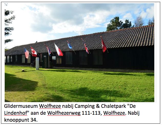
At purchasing point 34 in Wolfheze there is a Glider Museum where you can view a Horsa glider.
In the town of Driel at purchase point 59 there is a museum where the Polish contribution to Market Garden is highlighted.
Every year from the beginning of August to the end of September, Renkum Center hosts an open-air exhibition of maxi photos (175x225cm) about the destruction of the village of Renkum during WWII.
There are listening stones with information panels at various places along the route where you can download information with your smartphone (go to www.infocentrum-slagomarnhem.nl).
Have fun and enjoy the scenery!
Offered by: Renkum Leeft.
Renkum Leeft is an initiative of some enthusiastic Renkumers. We want to connect, mobilize and activate. After all, you create a nice village together!
Operation Market Garden was intended to bring an accelerated end to the Second World War. The Arnhem-Nijmegen region played an important role in this. On September 17, "The Battle of Arnhem" began there. Operation Market Garden was the largest airborne operation in history. 10,000 paratroopers, 1,000 DC3 Skytrains, 500 Horsa Gliders, 500 Jeeps, 300 artillery pieces and 1,500 fighter planes were deployed to start the battle.
The drop zones are spread out in various places in the landscape: drop zone Y is located on the south Ginkel near Ede between junctions 64 and 84 on the Wijde Veldweg. Dropzone X and Z are located in Renkum between junctions 84 and 82. In the direction of Wolfheze you will find drop zone S and in Oosterbeek you will find drop zone L. In the Betuwe near Driel there is drop zone K where the Poles landed.
This cycle route is 56 kilometers long and takes you through the entire area. You can get on anywhere. We started on the Ginkels heath near Ede where the Battle of Arnhem began. A large commemoration takes place here every year in Ede on the 3rd Saturday in September. Hundreds of paratroopers are dropped at the monument to the fallen. An impressive spectacle.
During the 3rd weekend of September there is plenty to do along the route from Thursday to Sunday, in Renkum, Oosterbeek and Arnhem. A visit is therefore more than worthwhile. You can attend many activities in the context of commemorating the Battle of Arnhem.
Sights:
The Airborne Museum in Oosterbeek near junction 38. The museum is located in the villa where General Urquhart had his headquarters. More than 100,000 people visit the museum every year.
An information center has been set up at the John Frost Bridge in Arnhem (between junctions 35 and 52).
At purchasing point 34 in Wolfheze there is a Glider Museum where you can view a Horsa glider.
In the town of Driel at purchase point 59 there is a museum where the Polish contribution to Market Garden is highlighted.
Every year from the beginning of August to the end of September, Renkum Center hosts an open-air exhibition of maxi photos (175x225cm) about the destruction of the village of Renkum during WWII.
There are listening stones with information panels at various places along the route where you can download information with your smartphone (go to www.infocentrum-slagomarnhem.nl).
Have fun and enjoy the scenery!
Offered by: Renkum Leeft.
Renkum Leeft is an initiative of some enthusiastic Renkumers. We want to connect, mobilize and activate. After all, you create a nice village together!
Height Profile
You do not want to miss this
Below you will find various suggestions for breaks that you can visit during your route. These are divided into different categories, making it easy for you to choose.

Directions
| # | Description | Distance | |
|---|---|---|---|
20 | 20 (Dorpsstraat, 6871AC, Renkum, Gelderland, The Netherlands) | 0.00 km | |
2 | 2 (6871DS, Renkum, Gelderland, The Netherlands) | 0.29 km | |
8 | 8 (6866CJ, Renkum, Gelderland, The Netherlands) | 1.91 km | |
10 | 10 (6866DW, Renkum, Gelderland, The Netherlands) | 2.43 km | |
9 | 9 (6865NG, Renkum, Gelderland, The Netherlands) | 4.13 km | |
37 | 37 (6865ND, Renkum, Gelderland, The Netherlands) | 5.30 km |
Place name directory
Reviews
Read the experiences of others below. This way you find out what score the route has received and you can decide whether this route is for you. Have fun!
Embed this page </>
See Routiq in...